Section 1.2 Four Quadrants
In this section we will learn about the four quadrants in the Cartesian Plane and relate it to the Hawaiian Star Compass. We will begin with an introduction to the Hawaiian Star Compass and the Micronesian Paafu.
Subsection 1.2.1 Micronesia
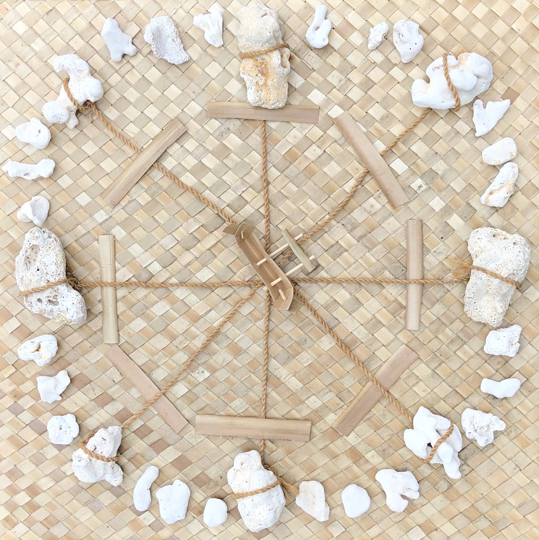
Navigators in Micronesia utilize the paafu mat or map (shown in Figure 1.2.1). It is often misunderstood and misinterpreted as a Star “Compass” due to its use of stars and constellations for direction finding. However, paafu serves a different purpose and is not equivalent to the cardinal directionality marked by compasses (North, South, East, and West). Instead, it is a learning and teaching tool designed to teach the locational positions of islands, locales, or canoes relative to other places. This is achieved by observing the rising and setting points of stars and constellations, which act as markers for different locations.
A constellation is a cluster of stars whose shapes and meanings reflect and carry cultural significance. In modern society, a well-known cluster of stars in the southern hemisphere, shaped like a cruciform, is commonly referred to as the “Southern Cross.” However, for the Polowatese and other islanders from the Central Carolines region in the western Pacific islands, this same constellation resembles the triggerfish, and so it is named accordingly.
In the Central Carolines, the general location in the celestial sky where stars appear to rise after sundown is referred to as “tan.” This term is often mistakenly translated as “east” due to the modern association of stars (like the sun) with “rising” in the east. However, it’s important to note that “tan” means “rising” and not “eastward.”

Figure 1.2.2 orients the cardinal direction known as “east” at the top of the page, and so the top half of this diagram is also identified as “tan” – where stars appear to rise. The diagram illustrates the apparent path of stars across the sky each night and day (though most stars are not visible during the day) and throughout a year. In this system, the rising and presence of specific stars mark months, and these same stars will eventually set at a point horizontally opposite to where they rose. This point corresponds to the cardinal direction known as “west,” which is referred to as “tolon” – the area where the stars “set” or go down.
In the paafu “map” shown in Figure 1.2.2, a canoe is placed at the center, and the star called Mailap (Altair) marks due east. The time and location when Mailap rises are referred to as “Tan Mailap” (rising Mailap), while the time and place it sets are referred to as “Tolon Mailap” (setting Mailap). The map’s orientation places east, or the rising points of the navigation or paafu stars, at the top of the circle, and west, or the setting points of these stars, at the bottom of the circle. As a map, paafu uses the rising and setting points of stars to mark places around a given locale, which is placed at the center of the circle. Table 1.2.3 displays the star and constellation names, provided in both Polowat and according to the International Astronomical Union, listed in the order of their rising during the third week of March in Polowat.
| Polowat | International Astronomical Union |
| Wenenwenenfuhmwaket | Polaris (always above the horizon) |
| Tan Mwarikar [Mahrah-ker] | Pleiades aka Seven Sisters |
| Tan Un [Oon] | Aldebaran |
| Tan Uliul [Ooh-lee-ool] | Orion’s Belt |
| Tan Harapwel [Ah-rah-pwol] | Gamma Corvus |
| Tan Mailapenefang [My Lap in a Fang] | Beta Ursa Minor in Big Dipper |
| Tan Up [Oop] | Crux or Southern Cross at Rising |
| Machemeas [Matche-may-ess] | Crux or S. Cross at |
| Tan Welo [Well-Ah] | Alpha Ursa Major in Big Dipper |
| Wenenwenenup [Wehneh wehnen Oop] | Crux or S. Cross at Meridian or upright |
| Tan Tumur [Two More] | Antares or Scorpio’s tail |
| Tan Maharuw [Maa-Haa-Roo] | Shaula or Scorpio’s stinger |
| Tan Mol [Mohl] | Vega |
| Tan Mailap [My Lap] | Altair |
| Tan Paiefung [Pie Efung] | Gamma Aquila |
| Tan Paior [Pie Or] | Beta Aquila |
| Tan Ukinik [Icky Nick] | Cassioepea |
Paafu can also be used to identify the direction in which moving objects, such as canoes, or creatures like birds, fish, and humans, are heading or coming from. This version of paafu utilizes the Polowat dialect of the Chuukese language, as used by members of the Weriyeng School of navigation.
Subsection 1.2.2 Hawaiʻi
With the aim of reviving wayfinding in Hawaiʻi, Nainoa Thompson journeyed to the island of Satawal in the Federated States of Micronesia to learn from master navigator Mau Piailug, affectionately known as Papa Mau. Using this knowledge, Thompson adopted the paafu method, leading to the creation of the Hawaiian Star Compass, also referred to as the Kūkuluokalani (Figure 1.2.4).
In the star compass, featuring the figure of an ʻiwa or great frigatebird at its center, Thompson divides the visual horizon into 32 equidistant points around a circle, referred to as houses. Each house in the Hawaiian Star Compass represents a specific space on the horizon (

The four cardinal points align with particular houses. Stars rise from the horizon called Hikina (“To Arrive”) or East and set on the horizon called Komohana (“To Enter”) or West. If you face Komohana (West) with your back towards Hikina (East), your right will point towards ʻĀkau (“Right”) or North, and your left will point towards Hema (“Left”) or South. The Hawaiian Star Compass is oriented with North at the top.
The star compass is divided into four quadrants, each named after winds in Hawaiʻi. Koʻolau is the Northeast quadrant named for the trade winds; Hoʻolua is the Northwest quadrant, Kona is the Southwest quadrant; and Malanai is the Southeast quadrant.
Each house on the star compass is given a name. The corresponding houses in the east and west share the same name. Starting from the east or west and moving northwards and southwards, the first house on either side of Hikina (East) and Komohana (West) is called Lā (Sun). It is followed by ʻĀina (Land), Noio (Tern), Manu (Bird), Nālani (Heavens), Nā Leo (Voices), and Haka (Empty). The 32 houses in the Hawaiian Star Compass correspond to the points of the 32-wind compass rose (Table 1.2.5).
| Star Compass | 32 Point Compass | Star Compass | 32 Point Compass | ||
| House | Symbol | Name | House | Symbol | Name |
| Hikina | E | East | Komohana | W | West |
| Lā Koʻolau | EbN | East by North | Lā Kona | WbS | West by South |
| ʻĀina Koʻolau | ENE | East-northeast | ʻĀina Kona | WSW | West-southwest |
| Noio Koʻolau | NEbE | Northeast by East | Noio Kona | SWbW | Southwest by West |
| Manu Koʻolau | NE | Northeast | Manu Kona | SW | Southwest |
| Nālani Koʻolau | NEbN | Northeast by North | Nālani Kona | SWbS | Southwest by South |
| Nā Leo Koʻolau | NNE | North-northeast | Nā Leo Kona | SSW | South-southwest |
| Haka Koʻolau | NbE | North by east | Haka Kona | SbW | South by West |
| ʻĀkau | N | North | Hema | S | South |
| Haka Hoʻolua | NbW | North by West | Haka Malanai | SbE | South by East |
| Nā Leo Hoʻolua | NNW | North-northwest | Nā Leo Malanai | SSE | South-southeast |
| Nālani Hoʻolua | NWbN | Northwest by North | Nālani Malanai | SEbS | Southeast by South |
| Manu Hoʻolua | NW | Northwest | Manu Malanai | SE | Southeast |
| Noio Hoʻolua | NWbW | Northwest by West | Noio Malanai | SEbE | Southeast by East |
| ʻĀina Hoʻolua | WNW | West-northwest | ʻĀina Malanai | ESE | East-southeast |
| Lā Hoʻolua | WbN | West by North | Lā Malanai | EbS | East by South |
Celestial bodies move along parallel paths across the sky from East to West, rising and setting in the same house, remaining in its hemisphere. For example, if a star arrives in the Koʻolau (northeastern) quadrant in the star house ʻĀina, it will arc overhead, staying in the northern hemisphere, and enter the horizon in the same house it arrived in, ʻĀina, but in the Hoʻolua (northwestern) quadrant (see Figure 1.2.6). Similarly, if a star arrives in the Malanai (southeastern) quadrant in the house Lā, it will remain in the southern hemisphere as it arcs overhead and enters the horizon in the house Lā in the Kona (southwestern) quadrant.
The star compass also serves as a guide for determining direction based on wind and ocean swells. As the wind and swells move, they intersect the star compass diagonally. For example, if a wind blows from the house Noio in the Koʻolau (northeast) quadrant, it will blow in the direction of the Kona (southwest) quadrant and eventually exit in the same house, Noio.
Subsection 1.2.3 Direction
Directions are very important. From Hawaiʻi, flying 3,000 miles in the East-West direction could take you to North America or to Asia, depending on which direction you are flying towards. In the Star Compass, the celestial objects travel along the Hikina-Komohana (East-West) direction. In math, we can call this direction the
Identify a point in Noio Kona.
Keeping in mind what we just did, without looking, identify a point in Noio Hoʻolua, Noio Koʻolau, and Noio Malanai. You should be able to use the negatives to find those points.
Insert grid
Draw a waʻa on the coordinate plane and then determine the coordinates Distance problem on coordinate plane (vertical and horizontal only) using absolute values (can use fractions or decimals) Map the Moananuiakea voyage and have the students calculate the distance (superimpose map on coordinate plane)
Subsection 1.2.4 Lesson: Cartesian Plane and Hawaiian Star Compass Symmetry
Here is a lesson to introduce the Castesian Plane using the Hawaiian Star Compass
Subsubsection 1.2.4.1 Objective
The objectives for this lesson are the following:
- Understand the directional principles of the Hawaiian star compass.
- Learn how to represent points on the Cartesian plane using ordered pairs.
- Relate the quadrants of the Hawaiian star compass to those of the Cartesian plane.
- Apply coordinate knowledge to solve distance problems.
- Utilize the Cartesian plane to map real-world scenarios.
Subsubsection 1.2.4.2 Materials
You will need the following materials
- Long pieces of string
- Objects (e.g., rocks, water bottles) for creating a compass in the classroom
- Grid paper or a coordinate plane grid
- Map of Moananuiakea voyage
- Ruler
Subsubsection 1.2.4.3 Procedure
Here are the steps
- Begin by explaining the directional principles of the Hawaiian star compass. Emphasize the East-West (Hikina-Komohana) and North-South (ʻĀkau-Hema) directions, relating them to the Cartesian plane’s
- Discuss how coordinates work, using ordered pairs to represent points on Earth and the Cartesian plane.
- Set up a compass in the classroom using string and objects. Have students stand at the center (origin) and practice moving in different directions, identifying their coordinates.
- Ask students to identify points in different Hawaiian compass houses and quadrants, reinforcing the concept of coordinates.
- Introduce the Cartesian quadrants (I, II, III, IV) and explain their placement on the Cartesian plane, relating them to the Hawaiian star compass quadrants.
- Discuss the symmetry between the Hawaiian star compass and the Cartesian plane.
- Have students practice identifying points in specific Hawaiian compass houses and quadrants, using negative values.
- Provide grid paper or a coordinate plane grid. Ask students to draw a waʻa and determine its coordinates.
- Present distance problems on the coordinate plane, focusing on vertical and horizontal distances. Encourage the use of absolute values
- Map the Moananuiakea voyage on the coordinate plane, allowing students to calculate distances and explore real-world applications of coordinates.
Subsubsection 1.2.4.4 Assessment
Assess students based on their ability to
- Identify coordinates on the Hawaiian star compass.
- Relate quadrants in the Hawaiian star compass to those on the Cartesian plane.
- Draw and determine coordinates of objects on the coordinate plane.
- Solve distance problems using coordinates.
- Apply coordinate knowledge to map real-world scenarios.
Subsubsection 1.2.4.5 Homework
Assign exercises involving coordinates and distance problems on the coordinate plane for additional practice.
