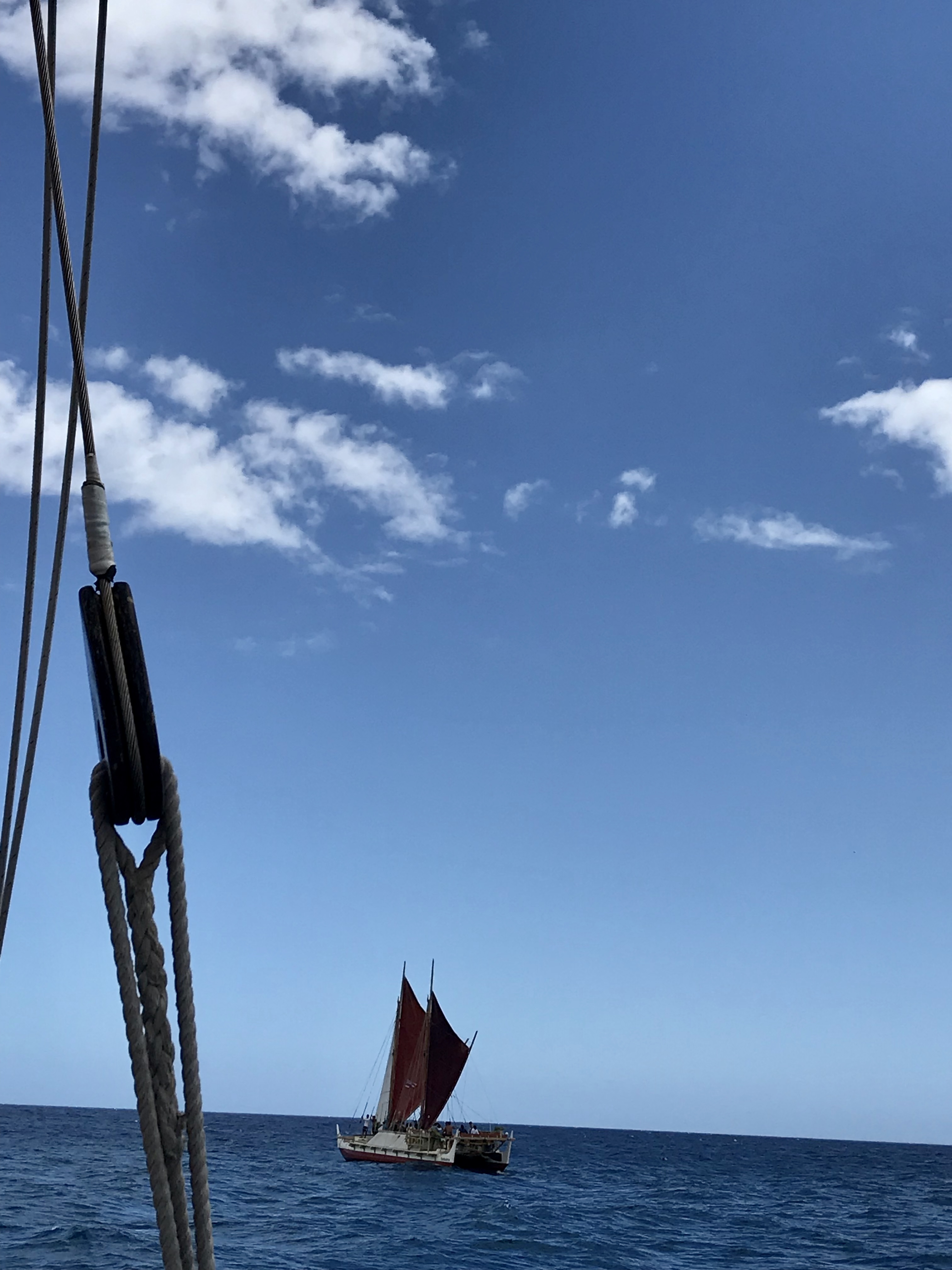
For centuries, voyagers have navigated vast distances across the Pacific, long before the use of magnetic compasses or modern instruments. They relied on observations of celestial bodies, such as stars and the sun, as well as natural elements like ocean patterns, winds, bird behaviors, and other environmental cues to determine their position relative to known landmarks such as islands, reefs, and continents. Over time, much of this traditional navigational knowledge was lost in many parts of the Pacific. However, some islands, particularly in Micronesia and on Taumako Island in the Solomon Islands, managed to preserve the art and science of traditional navigation. These places continued to uphold the practice, teaching new generations to build ocean-going canoes and develop navigational skills based on profound knowledge of the natural world.
Subsection1.1.1Micronesia
Navigators in Micronesia utilize the paafu mat or map (shown in Figure 1.1.1). It is often misunderstood and misinterpreted as a Star “Compass” due to its use of stars and constellations for direction finding. However, paafu serves a different purpose and is not equivalent to the cardinal directionality marked by compasses (North, South, East, and West). Instead, it is a learning and teaching tool designed to teach the locational positions of islands, locales, or canoes relative to other places. This is achieved by observing the rising and setting points of stars and constellations, which act as markers for different locations.
Figure1.1.1.Paafu mat or map - Photo courtesy of Kānehūnāmoku Voyaging Academy.
A constellation is a cluster of stars whose shapes and meanings reflect and carry cultural significance. In modern society, a well-known cluster of stars in the southern hemisphere, shaped like a cruciform, is commonly referred to as the “Southern Cross.” However, for the people of Polowat and others from the Central Carolines region in the western Pacific, this same constellation resembles the triggerfish and is named accordingly.
In the Central Carolines, the general location in the celestial sky where stars appear to rise after sundown is referred to as “tan.” This term is often mistakenly translated as “east” due to the modern association of stars (like the sun) with “rising” in the east. However, it is important to note that “tan” means “rising” and not “eastward.”
Figure1.1.2.The paafu, or Micronesian Star Compass. Stars are identified using the Polowat dialect of the Chuukese language as it is used by members of the Weriyeng School of navigation.
Figure 1.1.2 orients the cardinal direction known as “east” at the top of the page, and so the top half of this diagram is also identified as “tan” – where stars appear to rise. The diagram illustrates the apparent path of stars across the sky each night and day (though most stars are not visible during the day) and throughout a year. In this system, the rising and presence of specific stars mark months, and these same stars will eventually set at a point horizontally opposite to where they rose. This point corresponds to the cardinal direction known as “west,” which is referred to as “tolon” – the area where the stars “set” or go down.
In the paafu “map” shown in Figure 1.1.2, a canoe is placed at the center, and the star called Mailap (Altair) marks due east. The time and location when Mailap rises are referred to as “Tan Mailap” (rising Mailap), while the time and place it sets are referred to as “Tolon Mailap” (setting Mailap). The map’s orientation places east, or the rising points of the navigation or paafu stars, at the top of the circle, and west, or the setting points of these stars, at the bottom of the circle. As a map, paafu uses the rising and setting points of stars to mark places around a given locale, which is placed at the center of the circle. Table 1.1.3 displays the star and constellation names, provided in both Polowat and according to the International Astronomical Union, listed in the order of their rising during the third week of March in Polowat.
Table1.1.3.Star and constellation names in Polowat.
Polowat
International Astronomical Union
Wenenwenenfuhmwaket
Polaris (always above the horizon)
Tan Mwarikar [Mahrah-ker]
Pleiades aka Seven Sisters
Tan Un [Oon]
Aldebaran
Tan Uliul [Ooh-lee-ool]
Orion’s Belt
Tan Harapwel [Ah-rah-pwol]
Gamma Corvus
Tan Mailapenefang [My Lap in a Fang]
Beta Ursa Minor in Big Dipper
Tan Up [Oop]
Crux or Southern Cross at Rising
Machemeas [Matche-may-ess]
Crux or S. Cross at \(45^{\circ}\) 1
The “Tan” prefix is not used for this position, because it is no longer rising.
Tan Welo [Well-Ah]
Alpha Ursa Major in Big Dipper
Wenenwenenup [Wehneh wehnen Oop]
Crux or S. Cross at Meridian or upright
Tan Tumur [Two More]
Antares or Scorpio’s tail
Tan Maharuw [Maa-Haa-Roo]
Shaula or Scorpio’s stinger
Tan Mol [Mohl]
Vega
Tan Mailap [My Lap]
Altair
Tan Paiefung [Pie Efung]
Gamma Aquila
Tan Paior [Pie Or]
Beta Aquila
Tan Ukinik [Icky Nick]
Cassiopeia
Paafu can also be used to identify the direction in which moving objects, such as canoes, or creatures such as birds, fish, and humans, are heading or coming from. This version of paafu utilizes the Polowat dialect of the Chuukese language, as used by members of the Weriyeng School of navigation.
Subsection1.1.2Hawaiʻi
With the aim of reviving wayfinding in Hawaiʻi, Nainoa Thompson journeyed to the island of Satawal in the Federated States of Micronesia to learn from master navigator Mau Piailug, affectionately known as Papa Mau. Using this knowledge, Thompson adopted the paafu method, leading to the creation of the Hawaiian Star Compass, also referred to as the Kūkuluokalani (Figure 1.1.4).
In the star compass, featuring the figure of an ʻiwa or great frigatebird at its center, Thompson divides the visual horizon into 32 equidistant points around a circle, referred to as houses. Each house in the Hawaiian Star Compass represents a distinct segment of the horizon—an arc of \(11.25^{\circ}\)—where celestial bodies such as the sun, stars, moon, and planets rise and set. In the same way that we use addresses to locate homes, each celestial body has its own address represented by these houses.
Figure1.1.4.Hawaiian Star Compass, also known as the Kūkuluokalani.
The four cardinal points align with particular houses. Stars rise from the horizon called Hikina (“To Arrive”) or East and set on the horizon called Komohana (“To Enter”) or West. If you face Komohana (West) with your back towards Hikina (East), your right will point towards ʻĀkau (“Right”) or North, and your left will point towards Hema (“Left”) or South. The Hawaiian Star Compass is oriented with North at the top.
The star compass is divided into four quadrants, each named after winds in Hawaiʻi. Koʻolau is the Northeast quadrant named for the trade winds; Hoʻolua is the Northwest quadrant, Kona is the Southwest quadrant; and Malanai is the Southeast quadrant.
Each house on the star compass is given a name. The corresponding houses in the east and west share the same name. Starting from the east or west and moving northwards and southwards, the first house on either side of Hikina (East) and Komohana (West) is called Lā (Sun). It is followed by ʻĀina (Land), Noio (Tern), Manu (Bird), Nālani (Heavens), Nā Leo (Voices), and Haka (Empty). The 32 houses in the Hawaiian Star Compass correspond to the points of the 32-wind compass rose (Table 1.1.5).
Table1.1.5.The houses of the Hawaiian Star Compass and the corresponding points on the 32-wind compass rose.
Star Compass
32 Point Compass
Star Compass
32 Point Compass
House
Symbol
Name
House
Symbol
Name
Hikina
E
East
Komohana
W
West
Lā Koʻolau
EbN
East by North
Lā Kona
WbS
West by South
ʻĀina Koʻolau
ENE
East-northeast
ʻĀina Kona
WSW
West-southwest
Noio Koʻolau
NEbE
Northeast by East
Noio Kona
SWbW
Southwest by West
Manu Koʻolau
NE
Northeast
Manu Kona
SW
Southwest
Nālani Koʻolau
NEbN
Northeast by North
Nālani Kona
SWbS
Southwest by South
Nā Leo Koʻolau
NNE
North-northeast
Nā Leo Kona
SSW
South-southwest
Haka Koʻolau
NbE
North by east
Haka Kona
SbW
South by West
ʻĀkau
N
North
Hema
S
South
Haka Hoʻolua
NbW
North by West
Haka Malanai
SbE
South by East
Nā Leo Hoʻolua
NNW
North-northwest
Nā Leo Malanai
SSE
South-southeast
Nālani Hoʻolua
NWbN
Northwest by North
Nālani Malanai
SEbS
Southeast by South
Manu Hoʻolua
NW
Northwest
Manu Malanai
SE
Southeast
Noio Hoʻolua
NWbW
Northwest by West
Noio Malanai
SEbE
Southeast by East
ʻĀina Hoʻolua
WNW
West-northwest
ʻĀina Malanai
ESE
East-southeast
Lā Hoʻolua
WbN
West by North
Lā Malanai
EbS
East by South
Celestial bodies move along parallel paths across the sky from East to West, rising and setting in the same house, remaining in the same hemisphere. For example, if a star arrives in the Koʻolau (northeast) quadrant in the star house ʻĀina, it will arc overhead, staying in the northern hemisphere, and enter the horizon in the same house it arrived in, ʻĀina, but in the Hoʻolua (northwest) quadrant (see Figure 1.1.6). Similarly, if a star arrives in the Malanai (southeast) quadrant in the house Lā, it will remain in the southern hemisphere as it arcs overhead and enters the horizon in the house Lā in the Kona (southwest) quadrant.
Figure1.1.6.In the celestial sphere, stars rise in the east, arc across the sky, and set in the west. Each star will both rise and set in the same house. If you are viewing the PDF or a printed copy, you can scan the QR code or follow the “Standalone” link to explore the interactive version online.
The star compass also serves as a guide for determining direction based on wind and ocean swells. As the wind and swells move, they intersect the star compass diagonally. For example, if a wind blows from the house Noio in the Koʻolau (northeast) quadrant, it will blow in the direction of the Kona (southwest) quadrant and eventually exit in the same house, Noio.
Observations play a key role in determining direction using the star compass. At night, Thompson relies on approximately 220 stars, memorizing where they rise and set on the horizon to navigate. During the day, we can use the sun’s position on the horizon to gauge direction, but this method is only effective when the sun is near the horizon at sunrise and sunset. Alternatively, one can memorize the wind and wave directions, checking for any changes between sunrise and sunset to establish their current direction.
The canoe itself can serve as a compass, as shown in Figure 1.1.7. From the navigator’s seat on either corner of the stern (back) of the deck, we can observe features such as the rising sun and mark their positions on the Star Compass located on the canoe. It is important to note that the locations of the houses on this Star Compass are in relation to the canoe, not to a fixed map. For instance, only when the canoe is pointed towards the north will Hikina (East) be the house to the right. Depending on the canoe’s orientation, at other times, Hikina may appear several houses further up the deck.
Figure1.1.7.The deck of a canoe can be used as a compass to help crew and navigators.
Subsection1.1.3Marshall Islands
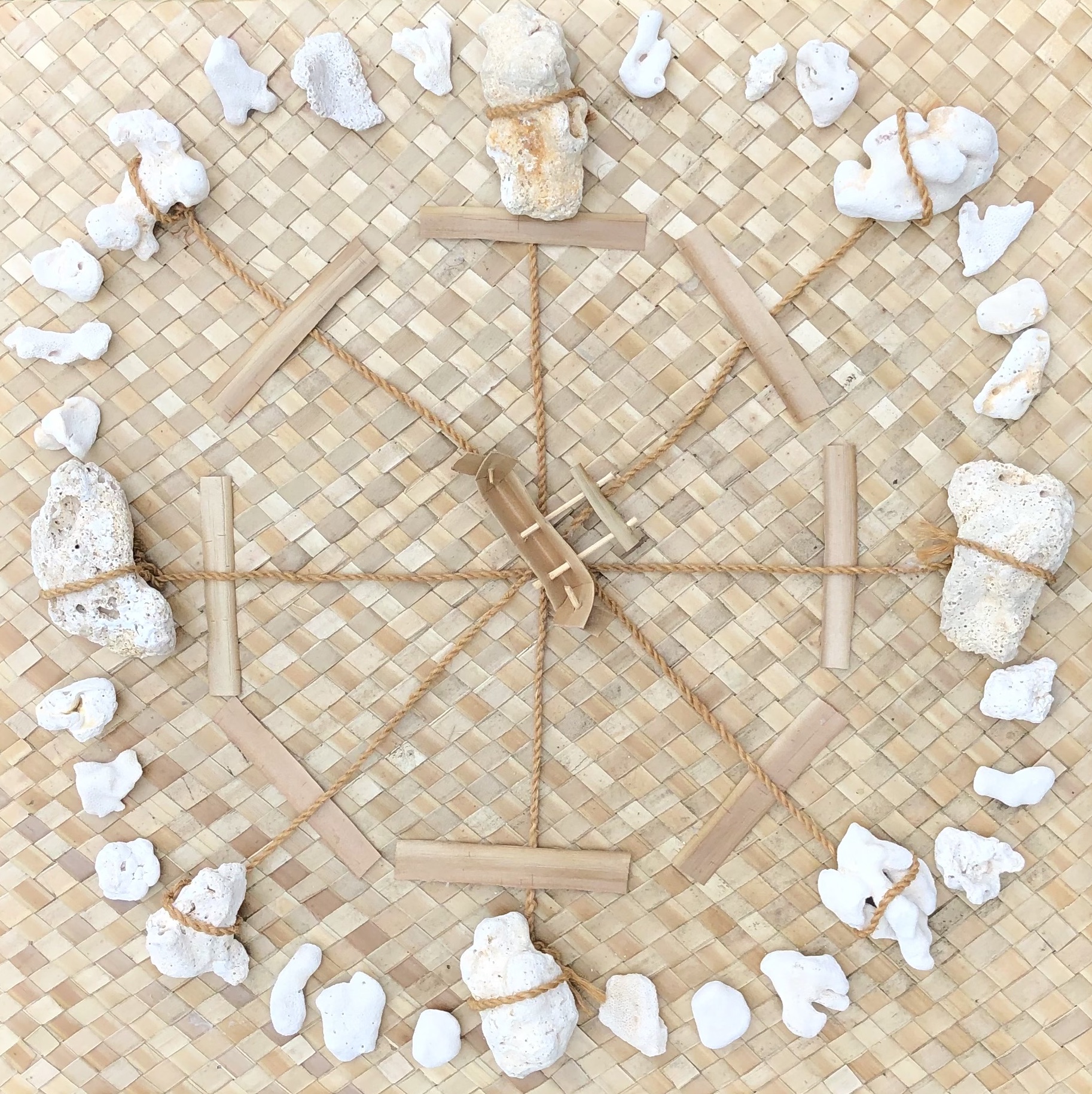
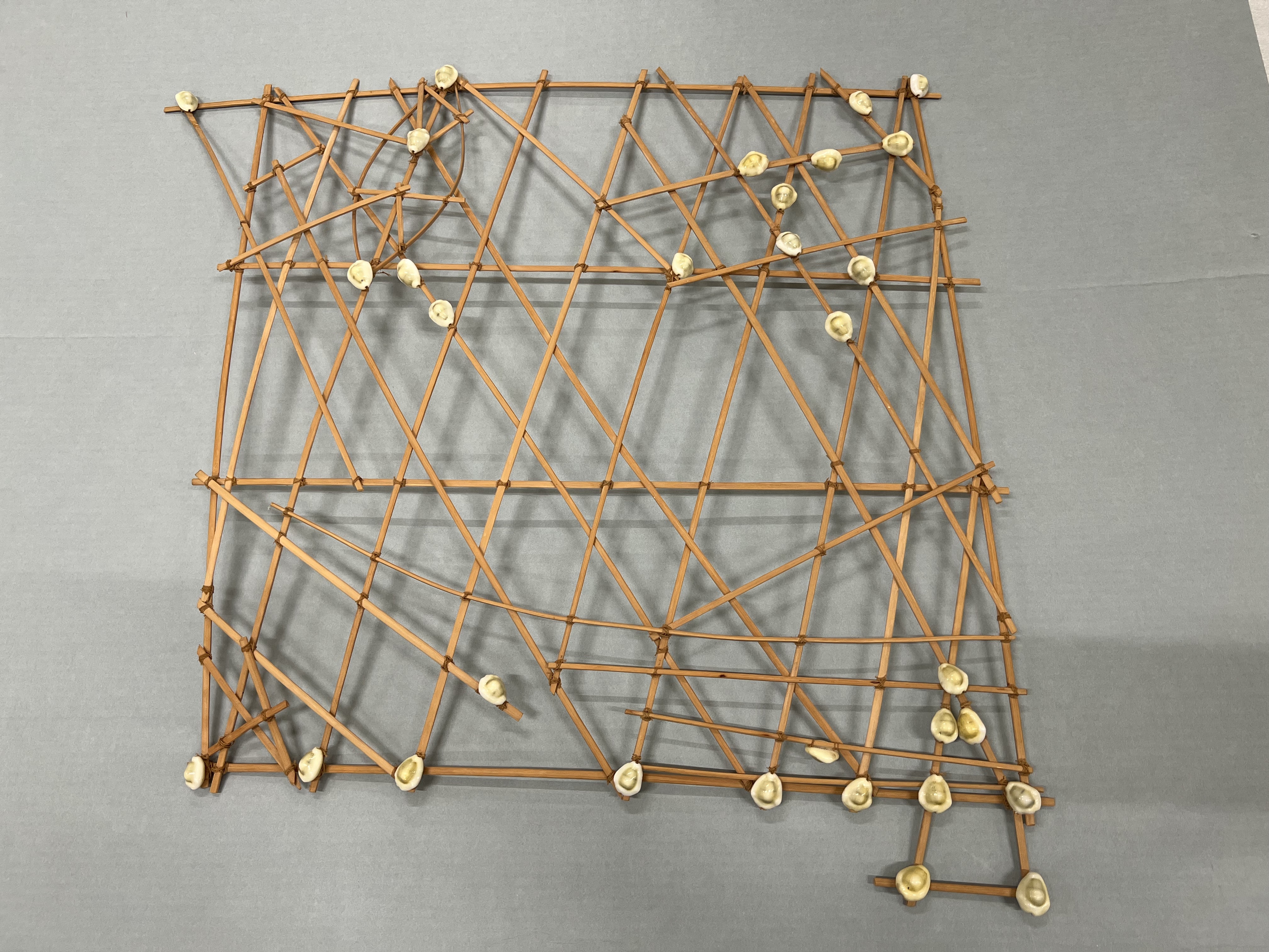
The Marshallese people use stick charts as navigational tools. These stick charts are constructed using a lattice-like structure made from curved and straight sticks, typically formed by tying together the midribs of coconut fronds. The curved sticks represent the islands and how they bend and refract the ocean swells, while the straight sticks symbolize the major wave patterns in the surrounding waters.
The shells placed on the sticks indicate the relative locations of islands within the Marshall Islands archipelago. These shells serve as markers, helping navigators remember the positions of specific islands along their voyages.
Each stick chart is unique to its creator, reflecting their individual knowledge and experiences. The personalization of the stick charts allows navigators to develop a deep understanding of the ocean currents, wave patterns, and island locations in their specific region.
The stick charts serve as mental maps or navigational aids, allowing experienced navigators to visualize and recall the complex information while on their journeys. Navigators would memorize the stick charts, internalizing the knowledge embedded within them, enabling them to navigate the open ocean.
Figure1.1.8.Marshallese stick chart.
Subsection1.1.4Elsewhere in the Pacific
In addition to the star compass, many cultures across the Pacific use a wind compass. Similar to the star compass, the wind compass is also a mental construct.
Other Pacific Island cultures have also adapted the modern Hawaiian Star Compass to their languages, as illustrated in Figure 1.1.9.
(a)Cook Islands.
(b)Māori.
(c)Sāmoa.
Figure1.1.9.Examples of Star Compasses across the Pacific.
Exercises1.1.5Exercises
1.
Who developed the Hawaiian Star Compass?
Answer.
Nainoa Thompson
2.
The Hawaiian Star Compass was based on the Micronesian Star Compass, known as the paafu. Who shared the paafu with the Hawaiians?
Answer.
Mau Piailug or Papa Mau
Exercise Group.
According to the Hawaiian Star Compass, what is the name for
3.
North
Answer.
ʻĀkau
4.
East
Answer.
Hikina
5.
South
Answer.
Hema
6.
West
Answer.
Komohana
Exercise Group.
What is the Hawaiian name for winds in the
7.
Northeast quadrant
Answer.
Koʻolau
8.
Southeast quadrant
Answer.
Malanai
9.
Southwest quadrant
Answer.
Kona
10.
Northwest quadrant
Answer.
Hoʻolua
Exercise Group.
For each direction, identify the Hawaiian names of the corresponding house and quadrant in the Hawaiian Star Compass.
11.
Northwest by North
Answer.
Nālani Hoʻolua
12.
East-northeast
Answer.
ʻĀina Koʻolau
13.
North-northwest
Answer.
Nā Leo Hoʻolua
14.
Southeast
Answer.
Manu Malanai
15.
South by West
Answer.
Haka Kona
16.
East by South
Answer.
Lā Malanai
17.
Southwest by West
Answer.
Noio Kona
18.
Northeast by North
Answer.
Nālani Koʻolau
19.
South-southeast
Answer.
Nā Leo Malanai
20.
West-southwest
Answer.
ʻĀina Kona
Exercise Group.
Identify the corresponding point on the 32-wind compass for each house on the Hawaiian Star Compass.
21.
Nā Leo Kona
Answer.
South-southwest
22.
ʻĀina Malanai
Answer.
East-southeast
23.
ʻĀina Hoʻolua
Answer.
West-northwest
24.
Lā Koʻolau
Answer.
East by North
25.
Manu Koʻolau
Answer.
Northeast
26.
Haka Malanai
Answer.
South by East
27.
Nālani Kona
Answer.
Southwest by South
28.
Haka Hoʻolua
Answer.
North by West
29.
Noio Hoʻolua
Answer.
Northwest by West
30.
Noio Koʻolau
Answer.
Northeast by East
31.
The winter solstice in the southern hemisphere occurs around June 22. It is the time when the sun is at its lowest elevation in the sky, resulting in the shortest daylight of the year. During the winter solstice, the sun rises from its northernmost position, ʻĀina Koʻolau. In which house does the sun set during the winter solstice in the southern hemisphere?
Answer.
ʻĀina Hoʻolua
32.
The winter solstice in the northern hemisphere occurs around December 22 when the sun rises from its southernmost position, ʻĀina Malanai. In which house does the sun set during the winter solstice in the northern hemisphere?
Answer.
ʻĀina Kona
33.
Wind is coming from Nā Leo Kona. In which direction is the wind blowing?
Answer.
Nā Leo Koʻolau
34.
Current is coming from Noio Hoʻolua. In which direction is the current heading?